Flattening Globe Earth to get a better look
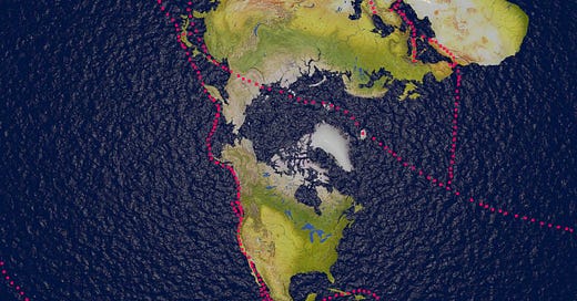
Imaginary Scenario Number 1: If we were to open the map of the world out flat and look at it with the north pole being in the centre and Antarctica around the outer edge, the configuration of the continents becomes more clear. Below is a very rough rendition of what that might look like. I have added pink dots to indicate where major fault lines might run in this scenario.
The expanses of water of course would be much smaller on globe earth. They have been filled in on this map. Also on a ball earth the tips of Africa, South America and Oceania (New Zealand and Australia) are far closer then we see on the flattened version. Let’s forget about the question of whether the earth is a ball, eliptical or even flat, and look at how the continents sit in relation to each other and to the access points to Antarctica. This is the ice continent where noone but the select few are allowed, and countries, including Russia, stand in agreement under the Antarctic treaty. In a similar way, Russia also stands in agreement with the US on the Schumann Resonances, Earthquake research, Nuclear disarmament and non proliferation treaties and the International Space Station.
When the map of the world is laid flat, the outline of the largest tectonic plate, the Pacific Plate looks quite straight. Looking from above we can clearly see that Russia sits very close to the centre of the map. Down either side of the globe there are two halves of a single fault line which lead to Antarctica. Along those two routes there seem to be a series of pinch points represented by territorial outposts, governed at various junctures by the west, with the east establishing ownership of other points.
Let’s imagine for one moment that the major faultlines running around the world are actually a sort of network of submarine super highways. At one southern end of the Pacific faultline we have South America, then a chain of islands heading east along the North and east Scotia Ridges and the Sandwich Trench. The Falkland Islands have been controlled by the British military since 1833 and were defended successfully in the Falklands War in 1982. They are accompanied by the South Sandwich Islands and South Georgia Island. The ridges then loop back west towards South Orkney Islands and another chain of islands approaching Antarctica.
At the ‘opposite’ southern end is New Zealand, a Commonwealth Country. The Macquarie ridge runs from the South Island south west then turning south east towards Antarctica. A number of south easterly orientated fracture zones run from the South Island up to and some just past the Antarctic Circle. Campbell and Auckland Islands sit to the west of these fractures on the Campbell plateau.
The connecting routes in the southern hemisphere to Antarctica are controlled either by the British, or by New Zealand, which is a Commonwealth country.
Using the superhighway to plunder Antarctica
Imaginary scenario number 2: If Antarctica is indeed rich in minerals and rare metals, industries would probably want to get their hands on them - industries rather than countries, as it is usually large global corporate mining and oil/gas extraction companies that lead the charge in gaining access to exclusive rights in new territories. There are probably plenty of other reasons to want to get to Antarctica. It is possible the Antarctic Treaty was put in place between global governments to protect the land from corporate and/or national greed. Let’s imagine some Russian prospectors wanted to get first dibs on these resources. Being furthest away from the prize geographically they would have to navigate the entire route.
In order to get from Russia to Antarctica there are number of possible routes. I use trenches rather than ridges as plate edge markers, as they seem more defined on the US Quarternary Faults webapp. For a similar reason, for possible routes within plate boundaries, I am using fracture zones.
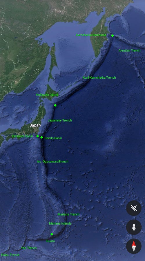
Route 1: From Eastern Russia, the Kamchatka Peninsula is positioned at the join between two of the Pacific Plate faultlines. The western route would take the prospectors down the Kuril-Kamchatka Trench for some 1,700 km until they came level with the east side of the Japanese island Hokkaido. They would then move through the Japanese and Izu-Ogasawara trenches, passing in to the deepest submarine structure on earth, the Mariana Trench. If you haven’t watched The Abyss, the sci-fi film released in 1989 about a race between the USSR and US to reach a science ship sunk near the Cayman Trough found off Central America, it is highly recommended. It gives some idea of the depth of structure of these giant submarine features. If, and of course this is a hypothetical scenario, the Japanese wanted to cut the Russian prospectors off at the pass, they would attempt this probably at the closest point to land, which is the intersection between the Katsuura and Bando Basins, just off the coast of Tokyo.
Once they arrive at the south end of the Mariana trench they come close to the next possible point of interception, the Island of Guam. Guam is a major military outpost and United States Territory. Andersen Airforce Base is cited on the north eastern flank close to the village of Yigo, and Naval Base Guam is at Apra Harbour to the North west side of the island.
The route then enters the Yap Trench from which there are two routes. One continues on to the Palau Trench. Germany bought the Palau Islands from the Spanish in 1899. Both the Mariana Islands and Palau Islands were the site of skirmishes between the Americans and Japanese in World War II. The Palau Islands are tropical, and being on the plate boundary, have volcanoes and are subject to earthquakes. Bizarrely, these islands had the highest CO2 emissions of all areas in the world in 2019, at a staggering 60 tonnes per person. This of course was blamed on local farming and fishing practices, though may well be related to the intense lightning storm activity noted in the region and indeed worldwide, during 2019.
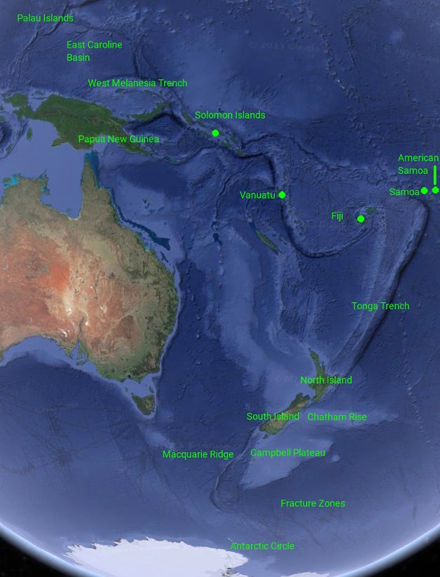
The second route branches off to the East Caroline Basin, joining up with the West Melanesian trench. If they took the Palau route, the route would take them the long way round through the New Guinea Trench to converge in the West Melanesian Trench, then continuing on to the Solomon Island. Recently China announced plans to establish a military base on the Soloman islands, which would allow, under the terms of the agreement, for them to send military, police and armed forces to assist in maintaining Social Order and for ‘other reasons’.
Our mining prospecters would then have another choice. They could travel in an easterly direction towards Samoa (Commonwealth). American Samoa sits further east with the deepest natural harbour in the South Pacific at Pago Pago that was a naval base from 1900-1951. American Samoa has one of the largest US Army Reserves recruitment operations. The US coastguard also now operate out of the island. The island sits just north east of the top end of the Kermadic-Tonga subduction zone. On September 28th 2009 a very strong 8.1 earthquake struck with epicentre on the outer edge of the zone at 18 km depth and generated a Tsunami that killed 170 people. The trench sloping was accompanied by underthrusting of two plates creating extensive faulting and the Tsunami.
Volcanoes behaving strangely
On 15th January 2022 the Hunga Tonga underwater volcano erupted. The ash plume reached 36 miles in to the atmosphere covering large parts of Tonga and surrounding islands in ash. The volcano sits in the Vava’u group of islands approximately 500km south of Samoa. The most interesting aspect of this explosion is that it stands in contrast with another volcanic eruption in Hawaii. The top edge of the crater was above water, but the centre of the crater was underwater. Therefore if the volcano was active before this erruption, periodic venting would have occurred, which presumably would allow water to enter. We are told by a Professor Arculus that Hunga Tonga has been ‘fairly active in the last 15 years’. Let’s head north to Hawaii briefly to explain why this is rather peculiar.
Hawaii has an active volcano, Kilauea, which sits to the south east of Mauna Loa on the same island. Though the area is not on a plate boundary it sits on the Molokai fracture zone, which runs across the Pacific Plate. The last eruption was in 2018, but just at the beginning of May this year it started to show increased seismic activity at the top of the volcano. Scientists are using a vehicle called Vibroseis to track the exact locations of the earthquakes and hopefully creating a three dimensional image of the inner workings of the volcano. The most peculiar thing about the Kilauea eruption was that Scientists believe RAIN was responsible for the prolonged four month eruption. You can see a series of images on this link showing how activity increased on the surface as cloud covered the volcano.
Therefore, if the Hunga Tonga Volcano had been showing signs of life for 15 years, and the centre of it’s crater and approximately a third of the side of it was underwater, why was it not continually exploding with exposure to water? Unless of course the rain that fell on the Hawaiian Kilauea, had something in it that was making the lava flare, perhaps some sort of chemical, one that has a high ignition point. Alternatively, was the Hunga Tonga erruption natural?
There are two other Volcanoes on Hawaii, one of which also poses questions. Mauna Kea on Hawaii has remained dormant for well over 4000 years but its very close neighbour, by approximately 43 km, Mauna Loa recently erupted. This volcano has erupted a total of 33 times since 1843, with the last eruption taking place in the auspicious 1984 before laying quiet until December 2022. According to Science News the volcano has been ‘grumbling for decades’, since 1999. The science team noticed that the signatures were very strange. None of the earthquakes were stronger than approximately M 1.5 and were occuring with remarkable regularity approximately every 7-12 minutes at a depth of exactly 25 Kilometres (remember this depth for later).
We will get to La Palma another time. So much weirdness going on there!
The final leg of Route 1
Going back to the previous diversion, the second branch from the Solomon Islands would take the prospecters past Vanuatu and Fiji, both Commonwealth Islands, before joining the Tonga Conduction Zone. During World War II Japan had advanced and seized what is now Papua New Guinea and the Solomon Islands. The US military, in an effort to stop the Japanese venturing further south, posted 50,000 soldiers on Vanuatu, on two military bases. That is a lot of soldiers! They built barracks, roads and an airstrip and welcomed other allied troops who were using it as a staging post. They were stationed there until 1945 after the Solomon Islands were taken back from the Japanese. Also in World War II the Fiji Infantry Regiment was formed, and were attached to the Australian and New Zealand army units. Again barracks, training facilities and airfields were established for use by the Allies.
After travelling the length of the Tonga subduction zone, the prospecters would arrive at Hikurangi Terrace to the east of New Zealand’s North Island. Then as they pass the South Island they traverse the Chatham Rise plateau, then on to the Campbell Plateau. They are nearly home free. The various fracture zones to the east of New Zealand might take them to within the Antarctic Circle, or they could skirt around New Zealand completely and make their approach through one of the more northern fracture zones. The Eltanin fracture zone system would carry them to the Palmer Basin and South Shetland Trough joining the tip of South America to Antarctica.
The Second Largest Earthquake on Record
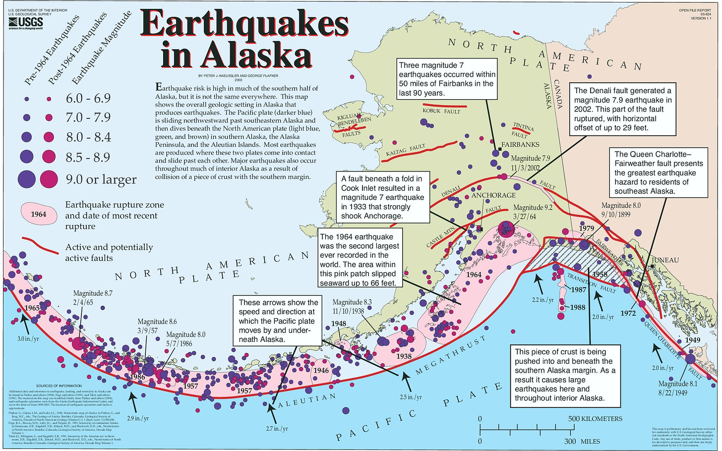
Route 2: Instead of heading south from Kamchatka the prospectors instead could turn eastwards across the Aleutian trench which spans from the Kamchatka Peninsula along the Aleutian Islands and the 800 km long Alaskan Peninsula. In 1964 on March 27th, Good Friday, the second strongest earthquake of the century hit the Prince William Sound close to the capital of Anchorage. It measured a moment magnitude of 9.2 and generated a tsunami that travelled across the whole Pacific Ocean. The shaking lasted for 4 minutes. There was widespread devastation of the towns in the Gulf of Alaska and damage along the coast of Canada. Joint Base Elmendorf–Richardson, stationed on the northern edge of Anchorage, was created from the amalgamation of Elmendorf Air Base and Fort Richardson, established in 1940. As well as uplift and subsurface rupture to the Prince William Sound area along the line of the fault, it also cause subsidence across the Anchorage section, where the Air Base and civilian airport were situated.
It was this earthquake that really kicked off the theory of plate tectonics, as scientists struggled to find a reason for the quake, they theorised it was caused by the movement of the Pacific Plate sliding underneath the North American Plate. This presentation by one of the scientists talks through how they assessed the earthquake, and worked on finding which fault was the epicentre of the earthquake.
A quick Detour to Vietnam
Imaginary Scenario Number 3: From 1955 to 1959 the United States had not fully entered the Vietnam War. They sent advisors to assist South Vietnam troops, but only started to build a larger troop presence there between 1959 and 1964. They amassed approximately 23,000 troops by 1964. If the United States was also making use of the submarine super highway, theoretically they could have sent troops through the Aleutian trench, via the Fairweather fault system from north western USA. They would then follow the same route as detailed above up to Japan, but then, instead of carrying on to the Mariana Trench, they could traverse across to Taiwan using the Nansei-Shoto Trench, to Manila through the Luzon Strait and across the South China Sea to Vietnam.
The Gulf of Tonkin incident when the North Vietnamese opened torpedo fire on the Maddox and other US naval vessels, only damaging one, is said to be the reason President Johnson decided to dramatically increase the number of troops heading to Vietnam. The number of troops in Vietnam rose by nearly 8 times the original count to a staggering184,300 from 1964 to 1965. Logistically it takes time to organise and transport troops, so this level of mobilisation within less than half a year of the attack seems remarkable, particularly as the attack did not even sink a vessel. What if this mass movement of troops was in response not to the torpedoing, but to the 1964 ‘Earthquake’?
Earthquake or Nuclear detonation?
The Prince William Sound earthquake took place some years after the USSR started nuclear testing in 1949 using the RDS-1. The US began testing in New Mexico in 1945, therefore nuclear technology by 1964 would have been significantly advanced. Is it possible that for some reason the USSR decided to block off the Aleutian route and damage supporting on-the-ground infrastructure in Anchorage? This same presentation points at dead trees and barnacles in the zone affected by the earthquake, pushing the land mass upwards some feet on the outer edge of the eruption. Barnacles of course need to be submerged in water in order to feed and survive, but could the tree stripping and losses be due to a blast wave?
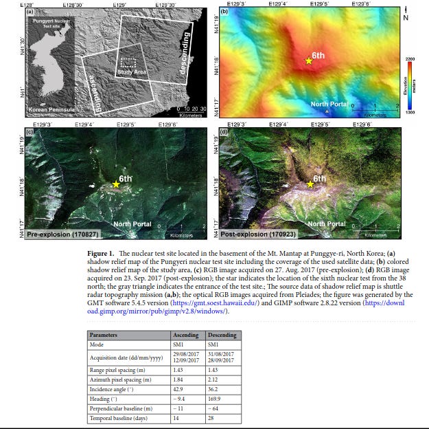
This article by Baek et al. (2017) discusses a massive land collapse and compaction caused by the North Korea nuclear test in 2017, which caused an artificial earthquake of M 6.1. In this image you can see there is a zone of ascending land mass and also a zone of descending land mass.
Interestingly USGS, the United States Geological Survey, states that the difference between telling a real earthquake from an earthquake produced by a nuclear explosion, is the number and strength of aftershocks. Nuclear explosions will create an earthquake much smaller than the original explosion and the epicentre would be much more shallow. There would also be fewer and smaller aftershocks. There were plenty of aftershocks after the initial earthquake in Alaska, some measuring over M6, and the epicentre was reported to be 25km deep.
The shock from the Korean 2017 nuclear test, 10 times stronger than the Hiroshima bomb, was followed by a strong 4.1 magnitude earthquake just 8.5 minutes after the initial explosion. Scientists puzzled over why this second shock occurred, and theory analysed by Cyranoski (2017) suggests that it may have been due to the post test collapse of a tunnel inside the testing site. This theory however was disproven by Won-Young Kim at Columbia University, who suggested that the second quake may have been a second explosion. This was later confirmed by North Koreans to have been the successful firing of a two stage thermonuclear bomb. The estimated depth of the test was only half a kilometre or 500 metres, significantly shallower than the Cannikin test and caused, as mentioned before depression and pushing up of the surface of the mountain and very much more shallow than the 25km deep 1964 Alaskan Earthquake.
Given the location of the Alaska earthquake, the issues the geologists had with coming up with a reason for it and the timing of it – Good Friday – could it be that a nuclear explosion had indeed occurred, and that the strong aftershocks were actually subsequent explosions? The subsidence over Anchorage suggests, similiarly to the Korean nuclear test earthquake, that a blast could well have created the depression, and the outward wave had caused the uprise in the region closer to the Pacific Plate.
Forensic (Nuclear) seismology has developed in to a science that today can detect the smallest of nuclear detonations. The Atomic Weapons Establishment in the United Kingdom, AWE Aldermaston and Foulness in the 1950’s then moved to AWE Blacknest in the 1960’s. The operation has monitored the testing and use of nuclear weapons leading up to the successful implementation of the Comprehensive Nuclear Test Ban Treaty. We talked in this article about refusals to ratified or sign the Treaty. It was only in 1963, the year before the Alaska earthquake, that all nuclear tests had been banned except for those conducted underground.
There are references to seismology being used to monitor nuclear testing throughout the CIA Reading Room. Therefore one must ask, as nuclear testing was proliferating throughout the 1960’s, is it possible that some, if not more of the earthquakes experienced, particularly along the Pacific Ocean Ring of Fire, could be a result of nuclear or other types of explosions?
Testing a 5 Megaton nuclear bomb
In 1971 Alaskans testified at the Atomic Energy Commission hearing about the proposed 5 megaton ‘Cannikin’ nuclear test due to take place on Amchitka, one of the Aleutian Islands, which sits, perhaps not coincidentally, closer to the Soviet side of the Aleutian Trench. It also sits at the juncture of the Bower’s Ridge to the west of the USSR Naval and Air military outpost on Adak Island which was used from World War II until decommissioning in 1992. The AEC had also run tests under the island in 1965 (1 year after the earthquake in Anchorage) and in 1969. The aim of the 1971 test was to see if it was possible to deactivate Soviet V2 missiles using X-ray and gamma ray radiation, rather than hitting the incoming missile directly. You can read about the Alaskan response at the 1971 hearing here. The site for the test had been chosen because the facility in Nevada was deemed to be unable to cope with the blast.
The Cannakin Project, which used a warhead from the anti-ballistic, W71 Spartan Missile, and part of the Sprint high altitude rocket ‘was buried more than 6,000 feet below the surface of the earth’, or over 1.8 kms, in a hole that was lined with steel casing. The hole was then backfilled. It was, according to the diagram shown in this video by Professor Simon Holland, buried in a massive bubble chamber lined with radiation detectors. The experiment took place on November 6, on 11 am, the day after a strong storm with winds measuring in excess of 100 miles per hour. The explosion did not trigger a Tsunami even though it was 1000 times bigger than the bomb dropped on Hiroshima. The explosion cause a body wave magnitude of 6.8 and a surface wave magnitude of 5.7. There was also localised ground movement away from the detonation point. You can see the explosion sequence here.
Just shortly after this test the USSR and US entered in to the Anti-Ballistic Missile Treaty, that would prevent both countries from developing anti missile systems, such as the one tested on 6th November 1971. It is likely that the knock-out design and range of this anti-ballistic missile worried the USSR enough to scare them in to signing the agreement on May 26th 1972, just six months later.
I have been a little side tracked by nuclear testing so in the next article will continue on Route 2 of the prospectors imaginary submarine journey to Antarctica, with all the obstacles they no doubt will encounter on the way.
Thanks as always to Seb for entertaining these crazy ideas!
Some questions until the next installment:
Looking at the diagram further up of earthquakes experienced along the Aleutian islands and ridge, why would the US Atomic Energy Commission choose to detonate their biggest nuclear test to date in 1971 along a highly unstable fault zone?
Why did the theory of plate tectonics only evolve after the 9.2 earthquake in Alaska in 1964?
Why is the entire ridge and trough route from Kamchatka to New Zealand so heavily guarded, and why did so many countries fight over possession of tiny islands?
What was so attractive about tiny islands in the middle of the ocean dotted with active volcanoes and tectonic plates?
What do you think?

